¿Ciclón subtropical a la vista? Ya formado
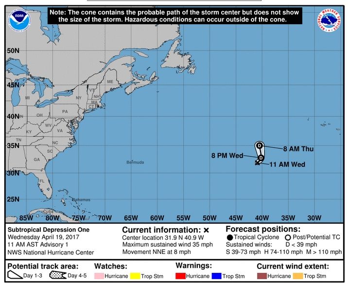
Invest 91L podría desarrollar una tormenta subtropical esta semana en el Atlántico Norte. Sería el primer abril nombrado tormenta desde 2003.Se ha formado el ciclón subtropical One
Actualizado:
Subtropical Depression One has formed in the central Atlantic and is no threat to land. Full advisory: https://t.co/tW4KeGdBFb pic.twitter.com/19TYPhW04y
— NHC Atlantic Ops (@NHC_Atlantic) 19 de abril de 2017
Según el NHC/CNH, hay cierta probabilidad:

Tropical Weather Outlook Text
ZCZC MIATWOAT ALLTTAA00 KNHC DDHHMM
Special Tropical Weather OutlookNWS National Hurricane Center Miami FL130 AM EDT Wed Apr 19 2017
For the North Atlantic...Caribbean Sea and the Gulf of Mexico:
1. A non-tropical low pressure system is located over the centralAtlantic more than 700 miles southwest of the Azores. Showers andthunderstorms have become a little better organized since yesterday,and winds to near gale force have developed northeast throughsoutheast of the well-defined center. This system still has theopportunity to become a subtropical cyclone during the next day orso before it becomes absorbed by a larger extratropical cyclone onThursday. The next Special Tropical Weather Outlook will be issuedby 2 PM EDT this afternoon. For additional information on thissystem, please see High Seas Forecasts issued by the NationalWeather Service.
* Formation chance through 48 hours...medium...50 percent
* Formation chance through 5 days...medium...50 percent
High Seas Forecasts issued by the National Weather Service can befound under AWIPS header NFDHSFAT1, WMO header FZNT01 KWBC, and onthe Web at http://www.opc.ncep.noaa.gov/shtml/NFDHSFAT1.shtml.
Forecaster Stewart
