Mapas de icebergs que se encontraría hoy el Titanic
¿Con qué se encontraría hoy el gran barco si estuviera en las aguas del Atlántico Norte? Cartas de icebergs se encuentran hoy disponibles gracias a las nuevas tecnologías y sistemas de vigilancia.
RAM
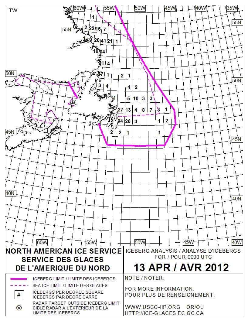
Se comparan dos cartas de icebergs de abril (salvando las diferencias) de 1912 y 2012.
Síguenos en Twitter: @RAM_meteo
Y en Facebook: RAMmeteorologia
Hoy 13 de abril de 2012 estamos a las puertas de que se cumplan los 100 años del hundimiento del Titanic.
¿Con qué se encontraría hoy el gran barco si estuviera en las aguas del Atlántico Norte?
Cartas de icebergs se encuentran hoy disponibles gracias a las nuevas tecnologías y sistemas de vigilancia. Un ejemplo es esta carta de análisis de icebergs: densidad, límites, etc.,:
Puedes analizar el archivo de cartas de icebers desde 1900 a 1958, por meses en:
http://researchers.imd.nrc.ca/~hillb/icedb/ice/ice_1900_1958.htm
Y para abril de 1912 se dispone de : http://researchers.imd.nrc.ca/~hillb/icedb/ice/ice_charts/1912ap.htm
Con su correspondiente carta de abril de 1912. Compárese con la de arriba y note las diferencias.Las referencias observacionales que se muestran fueron tomadas entre el 11 y 14 de abril de 1912, y en azul las referentes directas o indirectas al Titanic:
- Apr 11 French liner SS "Niagara" from Le Havre to New York collided with berg less than 10m from "Titanic's" eventual fate, and holed. Cunard liner SS "Carmania" responded to call for help. It passed 25 bergs of monstrous size, one estimated at 500' high. Speed reduced till engines barely turning. (JMB).
- Apr 12 41o37'N 50o26'W, 1 medium and 2 large bergs.
- Apr 12 41o40'N 50oW, 7 bergs and large quantities of pan ice.
- Apr 12 41o58'N 50o20'W numerous moderate sized bergs and extensive field ice.
- Apr 12-13 SS "Sachem" from Liverpool to Boston 43o13'N 48o49'W saw a big ice field and took 2 hours to pass it. In it, counted 14 bergs; morning of 13th, ran into more ice and went through it at reduced speed.
- Apr 13 SS "Borderer" from Calais 41o50'N 50o01'W for 30m along the direct charted course of steamers bound to New York, passed through heavy field ice, and in that distance counted 16 bergs. The ice extended as far north and south as the eye could reach.
- Apr 13 SS "Hellig Olav" from Copenhagen 41o43'N 49o51'W passed 3 large bergs; 41o30'N 50o08'W, 1 medium sized berg and field ice.
- Apr 14 SS "La Bretagne" from Havre 41o39'N 49o21'W and 50o21'W steamed through an ice field with numerous bergs, for 4 hours.
- Apr 14 SS "Titanic" (new) from Southampton to New York, collided with an iceberg at 10 0'clock pm, Apr 14, and foundered at 2:20 o'clock am (EST) 15th in about 41o16'N 50o14'W. The ship's boats with passengers, mostly women and children, and the boats' crews, in all numbering 868 persons, have been accounted for. The loss of life has been very large and is supposed to number 1234 persons. The rescued were picked up by the Cunarder "Carpathian" which is returning to New York with them.
- From "The Discovery of the Titanic", R.D.Ballard:
- SS "Caronia" reports bergs, growlers and field ice at 42oN from 49o to 51oW.
- SS "Noordam" reports much ice in about the same position.
- SS "Athinai" reports via SS "Baltic", passing icebergs and large quantities of field ice in 41o51'N 49o52'W.
- SS "Amerika" reports at 41o27'N 50o8'W a large berg.
- SS "Californian" reports 3 large bergs 3 miles to the S 42o3'N 49o9'W, stops for night at 42o5'N 50o7'W.
- SS "Mesaba" 42oN to 41o25'N, 49oW to 50o30'W saw large iceberg also field ice.
- RMS "Titanic" SOS est 41o46'N 50o14'W, actual 41o44'N 49o57'W.
- Ice barrier ~6m wide, stretches N & S 400m (down to ~41o36'N). (RDB).
- Apr 14 9 am; wireless message received by Capt. Smith of the "Titanic" from SS "Caronia", "Captain, Titanic, - west bound steamers report bergs, growlers and field ice in 42oN from 49oW - 51oW, 12 April, compliments - Barr. "Titanic's" position at that time would be about 43o35'N 43o50'W.
- 1:42 pm; wireless message received by Capt. Smith from SS "Baltic": "Capt. Smith, Titanic - Greek steamer "Athenia" reports passing bergs and large quantities of field ice today in 41o51'N 49o52'W ...". At this time "Titanic's" position was about 42o35'N 45o50'W.
- 1:45 pm; message from "Amerika" for Hydrographer at Washington relayed to the "Titanic", "Amerika" passed 2 large icebergs in 41o27'N 50o8'W on 14th."
- 7:30 pm; a 4th message received, from "Californian" to "Antillian", "6:30 pm apparent ship's time, 42o3'N 49o9'W 3 large bergs 5 miles to southward of us. Regards, Lord.
- 9:40 pm; received by the "Titanic", "from "Mesaba" to "Titanic" and all east bound ships. Ice report in 42oN to 41o25'N, 49oW to 50o30'W - saw much heavy pack ice and great number large icebergs. Also field ice. Weather good, clear.
- "Californian" stopped 10:20 pm, ship's time, when she was running into field ice which stretched as far as could be seen to the northward and southward in 42o5'N 50o7'W. (LM).
- Apr 14 SS "Pisa" 42o06'N 49o43'W encountered extensive field of ice and saw 7 bergs of considerable size.
- Apr 14 SS "Trautenfels" from Hamburg to Boston 42o01'N 49o53'W sighted 2 bergs fully 200' long and 50' high; soon after heavy field ice was encountered, which extended fro a distance of 30m and made it necessary for the steamer to run in a southwesterly direction for 25m to clear it; in the field ice, counted 30 bergs, some of which were berg large; off to the northward no clear water was seen, so that the captain estimated that the ice in that direction must have extended fully 30m.
- Apr 14 41o50'N 49o33'W a large berg.
- Apr 14 41o53'N 49o36'W a large berg.
- Apr 14 41o54'N 49o32'W a large berg.